

Hiking in the Philippines can mean climbing above the clouds on Mount Pulag, walking between Ifugao villages and rice terraces, or following volcanic ridges above the sea. The routes are spread across the islands, so a trip that looks short on a map may need an extra flight, an early start or an overnight stay.
Cover image by Nicko Melendres, Wikimedia Commons (CC BY-SA 4.0).
Rain, heat and local access rules can change a hiking plan. Protected areas and community routes may require registration, a permit or a local guide. Confirm the current trail status with the park or tourism office before travelling to a jump-off point.
Philippines hikes at a glance
| Hike | Region | Commitment | Main challenge |
|---|---|---|---|
| Mount Pulag via Ambangeg | Benguet | Overnight | Cold, exposed summit |
| Mount Ulap Ecotrail | Benguet | Full day | Long ridge walk and weather |
| Batad to Tappiya Falls | Ifugao | Half day or longer | Steep steps and wet paths |
| Hapao rice terraces | Ifugao | Half day | Village paths and uneven stonework |
| Marlboro Hill–Blue Soil traverse | Mountain Province | Half day | Uphill sections and changing weather |
| Mount Pinatubo crater | Tarlac | Half day | Heat, volcanic terrain and access rules |
| Masungi Discovery Trail | Rizal | Half day | Karst terrain and reservations |
| Mount Apo via Kapatagan | Davao del Sur | Multi-day | Permits, altitude and sustained climbing |
| Mount Hibok-Hibok | Camiguin | Full day | Steep volcanic trail |
| Osmeña Peak | Cebu | Short hike | Slippery rock and fog |
The 10 best hikes in the Philippines
Hike Mount Pulag via Ambangeg

The Ambangeg route is a common way to reach Mount Pulag, Luzon’s highest peak. The ascent passes through pine and mossy forest before opening onto grassland near the summit. The sunrise can be cold, even when the lowlands feel warm. The official Mount Pulag trip guide describes Ambangeg as the gentler approach, with campsites before the summit walk.
Register with the park and confirm the open trail, guide arrangements and overnight rules before you go. The Department of Tourism lists Mount Pulag’s four main trails; local trail conditions can change after storms or fire. Bring warm layers, rain protection and a headlamp, and follow the ranger briefing.
Walk the Mount Ulap Ecotrail

The Mount Ulap route crosses pine and grassland ridges between Ampucao and Santa Fe in Itogon, Benguet. The Ampucao barangay profile describes a roughly nine-kilometre, six-to-seven-hour walk past Ambanaw Paoay and Gungal Rock to the summit.
Start early, carry water and stay on the marked route. The trail crosses land with cultural significance to local residents, so keep out of restricted areas and follow guide instructions. Itogon temporarily suspended hiking during fire and heat risks, then lifted the suspension in September 2026; check the municipal advisory before setting out.
Walk from Batad to Tappiya Falls

Batad’s stone terraces curve around a steep mountainside above the village. The trail to Tappiya Falls drops through the terraces and continues to a waterfall pool; the return climb is strenuous, especially in humid weather.
Ask locally about trail conditions and community guide arrangements, and allow time to walk at your own pace. Stay on established paths and stone steps rather than crossing terrace walls or entering planted paddies. The Tourism Promotions Board’s Ifugao guide covers Batad, local villages and the Tappiya Falls trek.
Hike through the Hapao rice terraces

The Hapao–Baang–Nungulunan terrace cluster in Hungduan offers a slower walk through working Ifugao villages and steep paddies. The route is a good choice if you want to spend time among the terraces without making a high-summit climb.
Use a local guide where required and ask before photographing residents or entering private plots. The stone paths can be slick after rain. The Department of Tourism’s Ifugao guide describes the Hapao cluster and its community tourism; confirm the walk and access with the local tourism office.
Follow the Marlboro Hill–Blue Soil traverse

This Sagada route climbs to Marlboro Hill before continuing toward the Blue Soil Hills, also called Kaman-Utek. The Department of Tourism estimates four to five hours for the traverse. On a clear morning, the ridge opens onto wide views across Mountain Province.
Register through the local tourism system and arrange an accredited guide. Fog and rain can hide the path, and exposed sections offer little shelter. Sagada’s official visitor site lists registration and accredited guide organizations; confirm schedules and access before travelling.
Trek to Mount Pinatubo’s crater
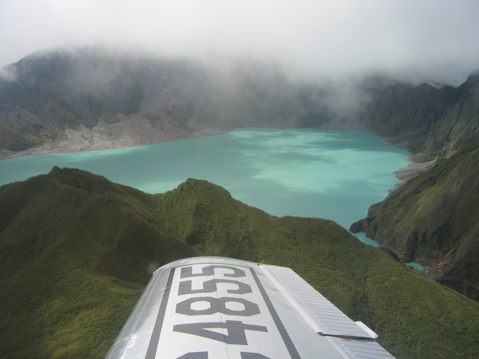
The route from Barangay Sta. Juliana in Capas begins with an off-road ride across lahar country, followed by a hike through an open volcanic valley to the crater. The walk is exposed, with little shade, and the route may change with weather and local access arrangements.
Book through the Capas Municipal Tourism Office or an approved operator, and check for closures before leaving. The 2025 Capas Citizen’s Charter gives current booking and service details. The route touches Aeta ancestral land; follow community guidance and the National Commission on Indigenous Peoples’ access statement.
Explore the Masungi Discovery Trail

The guided Discovery Trail in Rizal crosses limestone karst and forest through ropeways, platforms and narrow paths. It offers a very different day from the high mountain routes, and its guided format gives visitors a way to learn about the reserve’s conservation work.
Reserve directly with the Masungi Georeserve and check its age, group and equipment requirements. The full round takes about three to four hours. Wear shoes with grip, keep to the built trail and follow the ranger’s directions around the rock formations.
Climb Mount Apo via Kapatagan

Mount Apo rises above forest, volcanic ground and highland farms in Mindanao. The Kapatagan approach is a multi-day climb for hikers with the fitness and experience to handle a long ascent and changing conditions at altitude. The official Mount Apo route guide estimates two to three days for this trail.
Digos City requires climbers on its Kapatagan route to secure a permit, attend an orientation and use a guide. Its trekking permit page lists the current process and fees. Confirm the route’s status with the local government, prepare for cold rain and carry out all rubbish.
Climb Mount Hibok-Hibok on Camiguin

Mount Hibok-Hibok rises above Camiguin’s forests and coast. The climb follows volcanic slopes through the Timpoong-Hibok-Hibok Natural Monument, a protected area with several hiking routes and a crater lake.
Ask protected-area staff about the open trail, permit and guide requirements before booking. The Department of Tourism’s guide to the natural monument describes the Hibok-Hibok climb and the Itum and Yumbing trails. Bring water and a rain layer, and turn back if cloud or rain makes the route unsafe.
Climb Osmeña Peak

Osmeña Peak sits above Cebu’s Mantalongon highlands, where jagged limestone hills rise over farms and the coast. The walk from the usual trailhead is short, but fog, loose rock and wet ground can make the final ascent slippery.
Go with a local guide if conditions are poor, wear shoes with grip and wait for cloud to lift before moving across exposed rock. The Cebu Provincial Government’s account of the Mantalongon hike describes the trail and local farming community. Check access with Dalaguete’s tourism office before setting out.
Choosing a Philippines hike
For high peaks and cooler air, base a trip in the Cordillera or Mindanao. Batad, Hapao and Sagada combine village paths with mountain scenery; Masungi and Pinatubo are easier to pair with a stay near Manila. Camiguin and Cebu work well as island hikes, but leave room for weather delays between flights, ferries and trail days.
For other outdoor trips, see the guide to the Philippines’ best adventure activities.
Before setting out
- Confirm permits, registration, guide requirements and trail status with the local park or tourism office.
- Check weather, volcanic bulletins and local closure notices before each hike.
- Carry enough water, sun protection, rain layers and offline navigation for the route.
- Respect Indigenous communities, private farmland and protected-area rules.
- Leave flexible time around island flights and ferries, especially during wet weather.
Official planning sources
- Benguet destinations and Mount Pulag
- Mount Pulag planning guide
- Ampucao barangay profile and Mount Ulap Ecotrail
- Itogon suspension-lift notice, September 2026
- Ifugao tourism guide
- Sagada Tourism Office
- Capas Municipal Citizen’s Charter
- Masungi Georeserve Discovery Trail
- Digos City trekking permits
- Mount Apo planning guide
- Camiguin and Timpoong-Hibok-Hibok Natural Monument
- Cebu Provincial Tourism