

Spain's adventure routes cross very different country. In the north, limestone peaks and Atlantic rivers sit within reach of green valleys; farther south, the Sierra Nevada rises above Granada and the Cabo de Gata coast is shaped by old volcanoes. The Canary Islands add lava fields and high mountain trails, while the Balearics have long coastal paths and clear water.
That variety comes with real changes in weather, access and difficulty. A summer river descent depends on water levels, a mountain route can still be cold in warm months, and popular trails may need a shuttle or advance booking. Check local access and conditions before setting out, and use a qualified operator for technical water, rope or climbing activities.
Spain adventures at a glance
| Adventure | Standout destination | Intensity | Key requirement |
|---|---|---|---|
| Mountain hiking | Picos de Europa | Moderate–high | Weather and trail check |
| Long-distance walking | Camino de Santiago | High | Time and lodging plan |
| Canyoning | Sierra de Guara | High | Qualified canyon guide |
| White-water rafting | Noguera Pallaresa | Moderate–high | Confirm river flow |
| Surfing | Basque Country | Moderate–very high | Break suited to ability |
| Coastal walking | Menorca | Moderate | Water and sun protection |
The 20 best adventure activities in Spain
Walk the Cares Trail
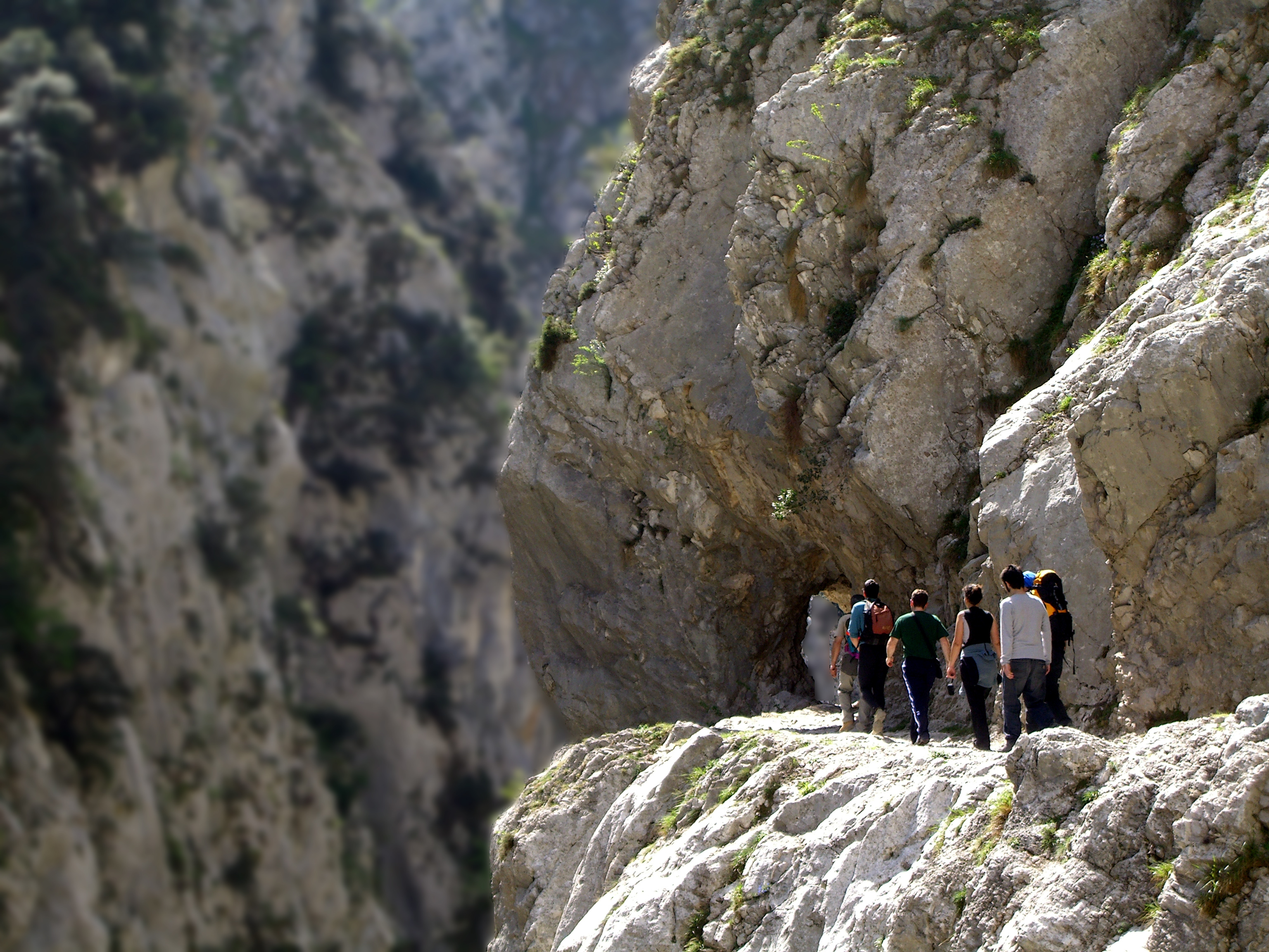
The Cares Trail threads through a deep gorge between Poncebos in Asturias and Caín in León. Much of the path is cut into the limestone wall above the river, with long stretches of exposed rock and little shade. It is a memorable day walk, but the out-and-back distance makes it longer than the valley scenery first suggests.
Start early, carry water and stay well back from the edge. The path is narrow in places, so give way carefully and keep children close. Check the Picos de Europa National Park for current notices, and arrange transport if you plan to walk only one way.
Hike the Cola de Caballo route in Ordesa
From Pradera de Ordesa, the route follows the Arazas River past waterfalls and beech forest to the Cola de Caballo waterfall beneath the Soaso cirque. The out-and-back walk is a full day for many visitors. Those looking for a harder circuit can return by the Senda de los Cazadores and Faja de Pelay, a longer route with more climbing.
Access to Pradera can be restricted at busy times, when buses run from Torla. Check the official route information and park notices before travelling. Mountain weather changes quickly; carry layers, food and enough water even on a clear morning.
Walk the Caminito del Rey

The Caminito del Rey follows a restored walkway through the Gaitanes Gorge in Málaga province. Boardwalks fixed to the gorge walls, high above the Guadalhorce, make this a dramatic route without requiring climbing skills. The one-way visit takes several hours once the approach paths and transport are included.
Tickets are required and should be booked through the official site. Wear secure shoes and check for wind or rain closures on the day. The height and narrow walkways can be difficult for people with vertigo.
Hike La Palma's Volcano Route

The GR 131 crosses the volcanic spine of La Palma, linking the island's south with the high rim of the Caldera de Taburiente. The best-known section crosses the Cumbre Vieja ridge among dark scoria cones and pine forest. Cloud, wind and sun exposure can make the walk feel more demanding than its map profile suggests.
Choose a stage that fits your fitness and transport, and check the island's trail status before leaving. Carry water and sun protection; there are long exposed sections. The official tourism trail guide lists the Volcano Route among Spain's major walks.
Climb Mulhacén in Sierra Nevada

Mulhacén is the highest mountain on the Iberian Peninsula. Routes from the Sierra Nevada high country climb across open, rocky terrain where altitude and weather matter more than technical climbing for most summer approaches. The mountain also anchors longer walks through the Sierra Nevada massif.
Plan around the season, route and your experience at altitude. Snow and cold can persist outside summer, and storms can arrive quickly. Check current access with the Sierra Nevada National Park, start with a reliable forecast and turn back if conditions deteriorate.
Trek the Camino de Santiago

The Camino is a network of walking and cycling routes to Santiago de Compostela, not one single trail. The French Way crosses northern Spain from the Pyrenees; the Northern Way follows the coast, while the Primitive Way crosses rugged country from Asturias. You can walk a short section or plan a multiweek crossing.
Book beds ahead on busy stretches and give yourself recovery time between long days. If you want the Compostela certificate, check the current distance and credential requirements before choosing your route. Spain's official Camino guide compares the main options.
Canyoneer in the Sierra de Guara

The limestone canyons of Sierra de Guara in Aragón draw canyoners for their pools, narrows, rappels and sculpted rock. Routes vary widely: some are introductory outings with a guide, while others require confident rope handling, swimming and careful reading of water conditions.
Book a qualified local guide if you lack canyoning experience, and ask about the route grade, equipment and exit plan. Water levels change with rain, even when the canyon entrance looks calm. Spain's tourism board describes canyoning areas and seasons across the country.
Raft the Noguera Pallaresa

The Noguera Pallaresa runs through the Catalan Pyrenees near Sort and Llavorsí, with commercial trips ranging from gentler sections to lively rapids. Spring melt often brings higher water, while operators adapt their routes to the flow and each group's experience.
Go with an established operator, wear the supplied helmet and flotation aid, and follow the guide's instructions. Ask which stretch is running and what the minimum age or swimming ability is before booking. The official Spain tourism guide notes that river conditions shape the rafting season.
Raft or kayak the Sella

The Sella in Asturias is best known for canoeing, with a popular stretch between Arriondas and Ribadesella. Guided rafting trips also run on suitable upper sections of the Sella and nearby rivers. The landscape shifts from wooded banks to wider river bends, and the trip can be adjusted to the flow and the operator's chosen section.
Use a licensed outfitter and check the day's water and weather conditions. Bring a change of clothes for after the trip, and keep a safe distance from other boats near narrow sections. The official tourism listing describes rafting options around Asturias and Cantabria.
Surf the Basque coast

The Basque coast has beach breaks and reef breaks, including the long, powerful wave at Mundaka in the Urdaibai estuary. Conditions vary with swell, tide and sand movement; the same beach can be welcoming to learners one day and unsuitable the next.
Take a lesson at a beach matched to your level, and ask about currents and local rules before paddling out. Mundaka is for experienced surfers when it is breaking well. Spain's surf and board sports guide helps compare destinations along the coast.
Windsurf or kitesurf in Tarifa

Tarifa sits between the Atlantic and Mediterranean at the Strait of Gibraltar, where reliable wind draws windsurfers and kitesurfers. Schools and rental shops make it possible to learn, while experienced riders can choose from several beaches depending on wind direction and local restrictions.
Take a lesson if you are new to either sport and keep clear of swimming zones and other users. Strong wind is not a beginner condition; ask the school which beach is appropriate that day. Check the local beach and safety guidance before heading out.
Kayak and snorkel Cabo de Gata

Along Almería's volcanic Cabo de Gata coast, guided sea-kayak trips pass cliffs, coves and beaches that are hard to reach by road. Some tours include time to snorkel in clear water. The protected landscape is dry and exposed, so even a short paddle needs planning for heat and sea conditions.
Choose a guide who checks wind and swell, wear a buoyancy aid and use reef-safe sun protection. Bring water and follow the guide's instructions about where landing is permitted. The Cabo de Gata-Níjar visitor guide covers kayak and snorkelling options.
Scuba dive at Cabo de Palos

The marine reserve around Cabo de Palos and the Hormigas Islands, off Murcia, is a major dive destination with reefs and historic wrecks. The exposed offshore sites are for divers with suitable training and conditions; sheltered alternatives are available closer to shore.
Dive with a licensed centre and match the site to your certification and recent experience. Currents and boat traffic call for close attention to the briefing. Confirm what equipment is included and whether the day’s sea state allows the planned dive. The official Cabo de Palos guide describes its marine reserve and dive sites.
Walk Menorca's Camí de Cavalls

The Camí de Cavalls circles Menorca on a historic coastal path, linking beaches, headlands, wetlands and small towns. Walkers can tackle the full loop over several days or choose a shorter section between coves. The route is marked, but its exposed stretches can be hot and dry in summer.
Carry more water than you expect to need, use sun protection and check bus or taxi options for a one-way walk. Stay on the marked path around dunes and private land. Spain’s official hiking portal lists the Camí de Cavalls among its island routes.
Hike the Costa Brava's Camí de Ronda

The Camí de Ronda links coastal paths and villages along the Costa Brava. A section near Begur or between Calella de Palafrugell and Llafranc makes a satisfying half-day walk, with stairways down to coves and headlands above the Mediterranean. The full coastal network is best planned in stages rather than treated as one continuous trail.
Wear shoes with grip for rocky steps and check local path closures after storms. In summer, start early and carry water; some coves have limited services. Spain's official hiking portal includes the Camí de Ronda among its coastal routes.
Take on the Chulilla hanging bridges

The Pantaneros trail near Chulilla in Valencia follows the Turia gorge and crosses suspension bridges above the river. It is a relatively short outing, but the narrow canyon, uneven paths and exposed bridges give it a sense of adventure. You can pair it with a walk to the village viewpoints.
Check local access rules and parking arrangements before you go, particularly on weekends. Spain’s official route listing has an overview of the trail. Keep to the marked trail and do not climb on the gorge walls; Chulilla is also a popular climbing area. Bring water and avoid the hottest part of the day in summer.
Climb a via ferrata in Catalonia

Via ferratas use fixed cables, rungs and bridges to make steep rock routes accessible with specialist safety gear. Catalonia has routes at different grades, including options around Montserrat and the Pyrenees. They still expose you to height and falling rock, so the grade and approach walk matter.
Go with a qualified guide if you have not used a via ferrata before. Wear a helmet and a certified via ferrata lanyard, and never attach yourself to the cable with improvised equipment. Check route closures and weather before setting off.
Hike the Garganta de los Infiernos

In Extremadura's Jerte Valley, the Garganta de los Infiernos trail crosses oak and chestnut woodland toward the Los Pilones natural pools, shaped by water in granite. The area has longer hiking routes as well as a shorter walk to the pools, where swimming is allowed only under local conditions.
Use marked paths, bring water and check seasonal restrictions before swimming. Summer weekends can be busy, and access rules may change to protect the reserve. Spain's tourism site has a guide to the Garganta de los Infiernos trail.
Walk the GR 221 across Mallorca

Mallorca's Dry Stone Route, the GR 221, crosses the Serra de Tramuntana through olive terraces, mountain passes and stone-built villages. You can hike a single stage or link several days between refuges and village accommodation. Some sections are steep and rocky despite the island's beach-holiday reputation.
Reserve refuge beds in advance and check which stages are open. Take a map, water and layers for exposed ridges; coastal temperatures do not predict conditions in the mountains. Check current stage and refuge information with Mallorca’s hiking authorities before setting out.
Explore lava tubes in Lanzarote

Lanzarote's volcanic landscape can be explored on foot and underground. At Cueva de los Verdes, a managed route passes through part of a lava tube formed by an eruption of the Corona volcano. The guided visit offers a different kind of adventure from exposed mountain or water routes.
Check opening times and ticket arrangements before travelling, and wear shoes suitable for uneven ground. Follow the guide and stay within the visitor route to protect the fragile cave. Pair the visit with a walk in the surrounding volcanic landscape only where access is permitted.